At the western end nearer Tourgis Point, the beach area, above and just around HWM has an interesting flora and also provides, near Fort Platte Saline, a nesting spot for one or two pairs of Ringed Plover Charadrius hiaticula, each year. Until this area was much altered in a huge storm in the mid 1970s it was one of two spots in the island, where the very rare (in both Alderney and the British Isles) Purple Spurge, Euphorbia peplis (figure 26 below), was to be found. After careful searching of both spots, by a number of people each year since, has failed to find it, this is now considered to be extinct.
The narrow moving dune area along Platte Saline is bound together with a heavy growth of Sand Couch Elytrigia juncea. Marram, Ammophila arenaria, common in the dunes at the other end of the island does not occur here. This part, little more than 5-10m wide and about 200m long, also holds a mixed population of occasional plants of mauve Hoary Stock Matthiola incana and frequent plants of Yellow Horned-poppy Glaucium flavum, the blue flowered, silver-leafed, Sea Holly Eryngium maritimum, yellowy-green Sea Spurge Euphorbia paralias, the pink/white striped flowers and fleshy heart-shaped green leaves of Sea Bindweed Calystegia soldanella, Sea Beet Beta vulgaris subsp. maritima with red-tinged inflorescences and the large purple and dull dark green leaves and huge white inflorescences of Sea Kale Crambe maritima (click link, photo on Crabby beach). These last two plants and the Docks, frequent along the edge of the sandy track separating the moving dunes from the flat grassy area, play host to considerable numbers of the Sandhill Snail Theba pissana (Figure 31 below), a Mediterranean species first seen in the larger Channel Islands in the 1860s, which was first noted in Alderney about 1930.
After the loss of the Purple Spurge, last recorded in 1973/4 and a considerable amount of erosion after a storm in February 1990 when the beach was dragged back, leaving a 3m. high "cliff" along most of this stretch, just above HWM (Fig. 25 below), over the next 3-4 years this whole shingle area was gradually replaced by the sea and the plants returned. Surviving plants on the beach area include a considerable seaward spreading of the Sand Couch into the replaced dunes, many more plants of the Sea Kale which, with its long tap root, regularly survives being buried under a depth of 0.25-1m. of beach grit and emerges again the next year. Sea Rocket Cakile maritima, plants with white flowers as well as the more usual blue/lavender colour occurring along the HWM and an occasional plant of Prickly Saltwort Salsola kali (Figure 32 below). .
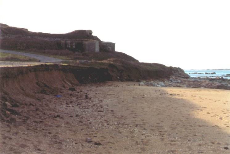 ... ..
Figure 24. Erosion at Platte Saline, W. end.
.
.
.
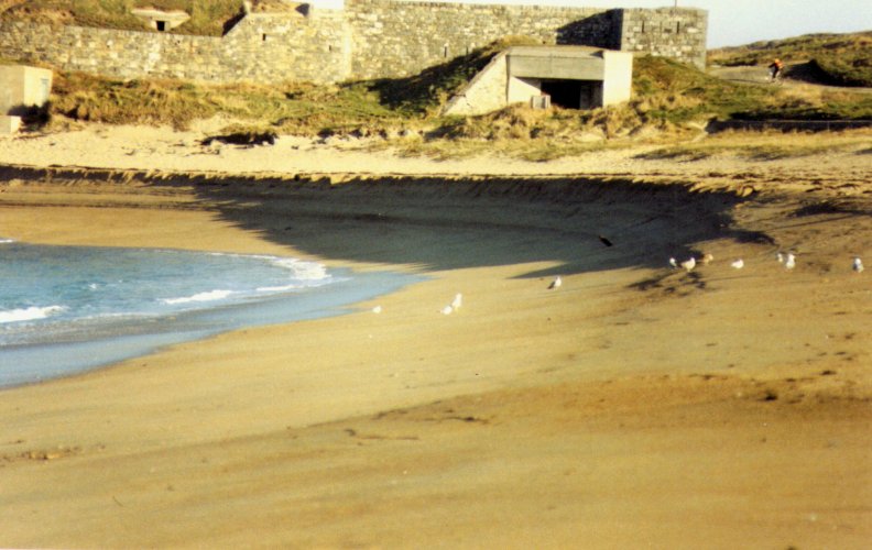
Figure 25. Effect of prolonged NE gales
moving shingle at E. end, Platte Saline
In 1997/9 the States of Alderney placed a considerable amount of large stones as foreshoreing along the area by the junction at the bottom of Tourgis Hill (at Fig. 24 above). The stone was brought from the old stock pile at Mannez quarry and interlain with a strong plastic reinforcing matting. The area behind this was backfilled with stone/soil hoggin and, despite a number of storms on this part of the coast, early in 2000, has still held successfully. The seat which was washed away in the earlier erosion was replaced somewhat further back from the top of this new barrier to provide a resting and viewing point for walkers.
Erosion and reformation of this part of the coast is a regular feature. Platte Saline Battery was built as a defence work about 1793 and turned into a small fort in the 1850s. At this time it was some way inland from the top of the beach and a narrow gauge railway ran on the seaward side of the fort to take stone right round the point, for the building of Fort Clonque. The Germans built a defensive sea wall some 5-7m. high along the eastern end of the bay during the last war, construction of which stopped just beside Fort Platte Saline. The top of the eastern end of this wall, level with the roadway, was roughly on the former line of the railway, then long gone.
When the houses along that part were rebuilt after the war, the inhabitants used ladders to get down to the beach from the top of the German wall. A fixed dune system has now built up to the top of the wall along towards Fort Doyle on the next headland and Northerly gales occasionally bring more shingle and grit over the top of this to blanket the roadway and invade the gardens of the houses. The flora of this area is similar to that at the western end, with the addition of a number of aliens, probably escaped from local gardens. These include Greater Quaking Grass Briza major (click link, photo on Platte Saline dunes), Weasel's-snout Misopates orontium, Alpine Toadflax Linaria alpina, Silver Ragwort Senecio cineraria (click link, photo on Crabby beach), and large patches of both the puce and yellow forms of Hottentot Fig (click links, photos at Platte Saline). The outer wall of the Fort Platte Saline collapsed onto the beach, where it still lies, when it was undermined by storms about 1960, the land on which the narrow gauge railway ran, having been eroded away long before that.
This part of Platte Saline is watered by a third stream. Originating in springs above Little Street on the south side of the Town, this now runs underground to the top of La Vallée and then down the steep slope (see next Region 4) to Platte Saline, where it turns along behind the houses and then runs North, to discharge onto the beach via a pipe through the base of the German sea wall. The sides of this part of the little stream are lined with more Great Willowherb, a few willows and a large patch of Blackthorn Prunus spinosa or one of its hybrids. The dryer areas just beyond the banks are home to a few Fuller's Teasels, Dipsacus sativus (click link, photo on Platte Saline), more Silver Ragwort, self-seeded from a nearby garden, Tree Mallow Lavatera arborea, Tree Lupin Lupinus arboreus (click link , photo on Platte Saline), Bird's-foot Trefoil Lotus corniculatus, and Pyramidal Orchids. Behind the sea wall, here well above the land surface and with its seaward side kept comparatively clear of shingle build up by the continuous flow of fresh water from the streams, large patches of Hottentot Fig and Sea Sandwort Honckenya peploides (click link), are to be found.
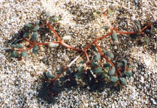
Figure 26. Purple Spurge at Crabby
Moving further east, we pass through the cutting in the headland, made for the passage of the narrow-gauge railway, to carry stone from the harbour junction towards Fort Clonque, for the construction of that fort, the conversion of the 1790's Platte Saline Battery to a fort and building Fort Doyle (click link, Fort on extreme right, cutting in centre), on the headland to our left. The part immediately above us here contains an almost buried German Bunker. Emerging from the cutting, Crabby Beach (click link, with Ambulance station beyond) lies about 4-5m below us. At present the island's main sewer outlet discharges untreated sewage into the sea off Doyle Point. The swift tidal currents, just offshore in the Swinge, rapidly disperse this for most of the time, but in the not too far distant future EU regulations may force Alderney to make alternative arrangements and install treatment facilities.
The old vraic road at this end of the beach, formerly passed down a slope on the far side of the roadway and accessed the beach through a tunnel under the road. This is now blocked up but the tunnel entrance remains visible on the beach side. The shingle here was the second site of the last remaining colonies in the British Isles of the Purple Spurge, referred to above. Its very specialised habitat requirements and seawater borne seeds gave hopes that it would re-establish itself from dormant seeds. Despite careful searching at the appropriate times for most of the years since, it has not returned and must now be considered extinct.
Above HWM most of the plant species already mentioned may be found in the shingle, with long established plants of Tamarisk (click link), and Duke of Argyl's Teaplant (click link) Lycium barbarum (or perhaps L. chinense), on the cliff edge. In the field across the road is another well established alien shrub, Hedge Fuchsia and in the grass along the top of the low cliff, plants of Eastern Gladiolus Gladiolus communis (click link) and the only colony of Bithynian Vetch (click link) Vicia bithynica in the island, thrive. The beach and York Hill Quarry, site of the Electricity Station across the road (click link, photo taken in 1952, with Fort Grosnez beyond), provide feeding and resting areas for a number of sea birds. Most commonly seen are the smaller Black-headed Larus ridibundus, and Mediterranean Gulls Larus melanocephalus, and Common Tern Sternus hirundo. In autumn considerable numbers of Herring L. argentatus and Black-backed Gulls, both Great L. marinus and Lesser L. fuscus, join the group. The quarry, one of the first to be excavated for stone to build the Breakwater and Fort Grosnez, is half filled with fresh water and is used now as cooling water for the Power Station alongside. The rim and walls of the quarry bear many plants of mauve Hoary Stock, (white specimens of which clothe the wall of The Cut a few yards beyond), and a single plant of the Wild Pear Pyrus pyraster (click link), the only specimen in the island. Shaped by the wind, this flowers freely, but rarely fruits.
.
We now come to the harbour area and the bare, former site of the huge stone-crusher, built around the turn of the century and demolished in the 1960s. This and the associated quarries gave work to a large part of the male population from the end of the Victorian harbour and Fort building works until the island was evacuated in 1940. Dust and small stone from the crusher and erosion of the mound on which the Breakwater was built, was gradually washed round by the tides, sometimes piled in banks high above HWM. These have formed the greeny-grey shingle and sand now found in Crabby Bay, formerly with golden sands and used as the "Ladies Beach" for swimming in Victorian times, when it was closed to men during the day and was accessed by steps down from the edge of the Fort Grosnez glacis at the harbour end, before the Stone Crusher was built.
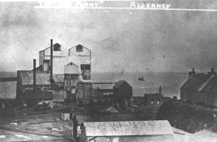
Figure 27. The original Stone Crusher in 1905
The grey stone from here has been used for many years since the last war as a source of stone for repairing Alderney's roads, but in 1999 the diminishing quantities available finally stopped this.
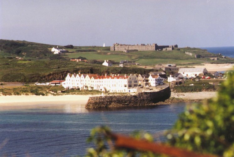
Figure 28. Old Harbour & warehouses,
Fort Tourgis and the navigation cone beyond
The construction of the Breakwater and Forts, from 1847 to 1870 caused an enormous change in the ecology of the area and of Braye Bay to the east of the New or Little Crabby Harbour. The "Old Harbour" formed by the Le Mesurier Pier, built in 1736, with the lower level Douglas Quay added in 1840, rapidly silted up and thus dried out at low tide, rendering it practically useless. The warehouses, built along Braye Street around 1736-50 to house smuggled and captured goods, (many now converted to Hotels), which had their cellars opening directly onto the beach to facilitate landing the goods, then became less easily accessible. The beach area, so popular today for bathing and as a tourist beach, gradually extended much further out to sea than formerly and the dune area thus formed had, towards the harbour end, (until this was filled in with spoil from the Banquage scheme in the early 1990s), a small dune slack area behind the first line of dunes, with an interesting salt-marsh flora and fauna. The construction of the Commercial Quay in 1899-1902, then made the landing of goods and passengers a much simpler, quicker and safer operation than it had been since the old harbour silted up.
The Breakwater, although now only half the length that it had reached when construction was abandoned in 1870 (and the second arm stretching out from Château à L'Étoc headland, intended to enclose the bay was never built), nevertheless still provides a sheltered anchorage for many cargo, fishing and pleasure boats and the occasional naval and cruise ships. The 8-900m. long, sunken part of the dismantled portion, the top of which is only about 8-10m. below the
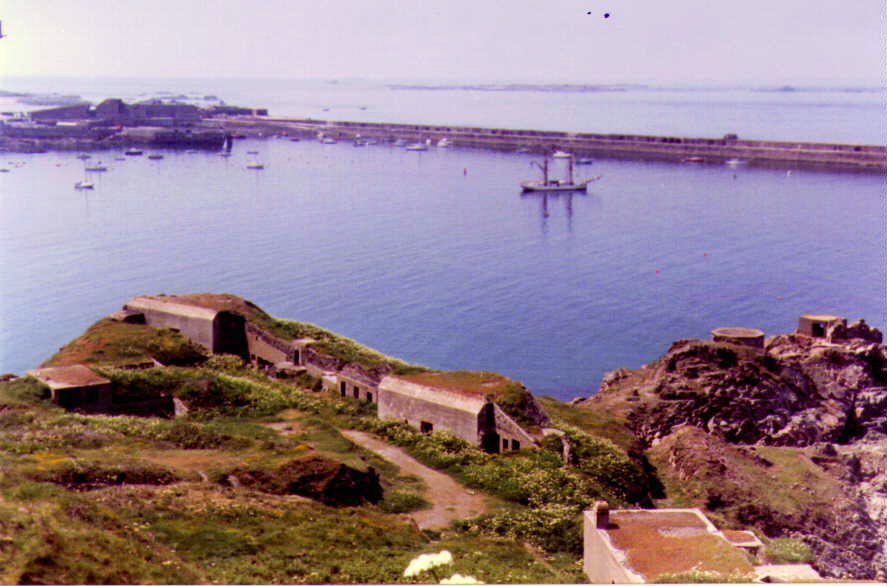 surface, still helps to keep the worst of the N & NW weather from the eastern end of the bay,at the same time presenting a navigational hazard to larger ships. In these conditions waves hitting the outside of the Breakwater frequently send a wall of spray into the air, as much as 50-60m. high in severe conditions. In certain NE weather conditions the bay experiences some very rough water flowing in through the open end and, from time to time vast quantities of sand are moved along the beach towards the west, exposing underlying rocks and shingle and flooding water, seaweed and rocks over the road along the eastern end; on some occasions badly eroding the low cliff here. A few weeks later the sand has usually moved back again leaving a large expanse of clean sandy beach once more.
.
Figure 29. General view of Braye Harbour from Fort Albert.
.....The island of Burhou can be seen in the background
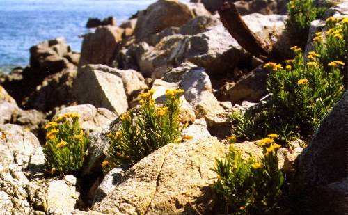
Figure 30. Golden Samphire
Fort Grosnez at the landward end of the Breakwater, the first of the forts to be constructed, has an interesting flora of salt-spray resistant plants on and around its outer walls, including Golden Samphire, quite rare in Alderney and not that common around the coasts of the other Channel Islands or England.
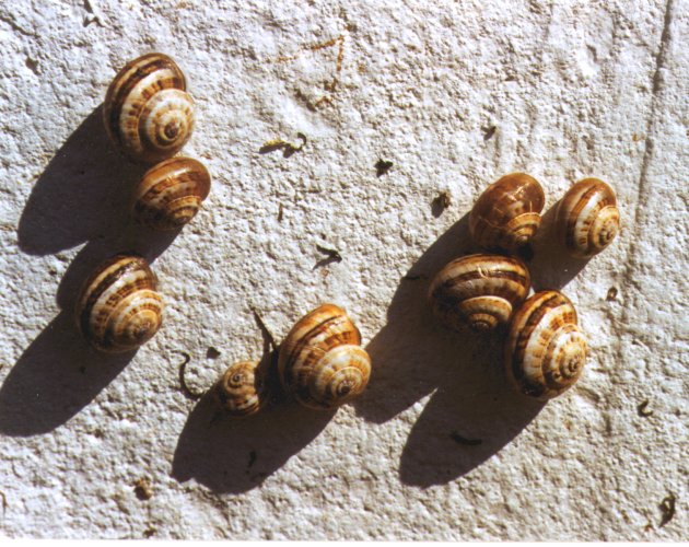
Figure 31. Sandhill snails
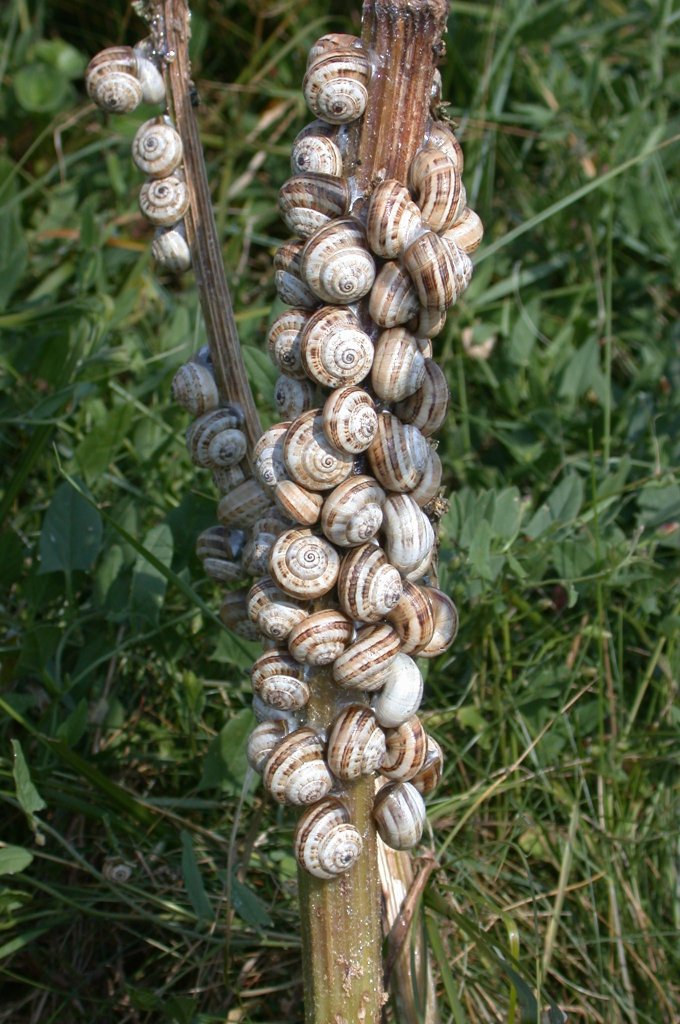
Figure 31a. Sandhill snails clustered on a dead Hogweed stem at Platte Saline
Until a few years ago, the only dune slack still existing in the island was to be found along about 2-300m of the curve of Braye Bay, starting near the left hand edge of Figure 28 and extending further to the East (left of picture). This left an area almost level with the beach and about 5-6m wide behind the first dune, occasionally flooded for short periods after storms. The flora of the area consisted of Sand Couch, Bramble, Sea Bindweed, Sea Spurge; Sea Beet and various Docks (both supporting a number of the Sandhill Snails); and several other of the common coastal sand dune plants. It also contained the only plant of Norway Maple, (Acer platanoides), which I have seen in the island outside gardens, presumably self-sown, and a small area of Due to a misguided attempt by the States to prevent possible erosion here, after a storm had badly damaged the sea wall along the eastern end of the bay and, at the same time, to dispose of a large amount of Victorian quarry spoil from the Banquage housing scheme on the other side of the road which forms the southern boundary of this region on the map Figure 2, the slack was completely filled in and a potentially important habitat was lost for ever.
...................................................
The beach at the foot of the dune in front of this area is still home to several of the plants listed in the previous paragraph and, in addition seems to be the principal site in the island where Prickly Saltwort Salsola kali (Figure 32) is to be found. Soapwort (Saponaria officialis) was also reported from about here in 1956, but has not been recorded since. Sea Rocket (Cakile maritima) is frequent here and also extending along the beach to the East, above the HWM.
In the splash zone just in front of dune areas, a number of flowering plants may be found growing in the sand or small shingle. Marram, Sand and Sea Couch-grasses, Sea Kale, Sea Beet, Sea Spurge, Spear-leaved and Babington's Orache, Sea Sandwort, Yellow Horned-poppy, Sea Bindweed, Sand Sedge and Buck's-horn Plantain being the commonest.
In summer Sea Lettuce and Enteromorpha will be noticed in the flat, shallow wet areas towards the bottom of the tide, especially where there is freshwater seepage in this area. Zostera, another flowering plant, is found in the sublittoral zone off several parts of the South coast, (see under Region 8), usually above the Laminarians, particularly where there is a muddy substrate.
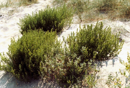 The area of Braye Common behind the dunes here extending out to the road, was formerly the site of one of the steam driven 19th century stone crushers. Small diorite stones emerge here whenever the surface grass is removed and in many years a large patch of the delicate, blue Pale Flax (Linum bienne) flowers here. A cutting through the dunes is to be found just beyond the former end of the dune slack and a small colony of Japanese Knotweed, (Fallopia japonica), flourishes just above it to the East.
The common, from here to the turn off to the Arsenal, is lined along the roadside by a number of New Zealand Cabbage Palms, (Cordyline australis), first planted here in the 1930s and giving a subtropical .....Figure 32. Prickly Saltwort below the dunes
appearance to the Bay area. They were badly cut back by the hurricane in October 1987, but most have survived and sprouted from the base, now reaching 2-4m in height. More are being planted in 2000. The common used to be grazed by the tethered Alderney cattle and mown once or twice a year for hay. This helped to keep the grass short and allowed many small plants to flourish including Pyramidal Orchids by the hundred. Alien plants appeared from time to time probably from seed dropped by birds or windblown. Two of the most unusual being Great Millet, (Sorghum bicolor), just beyond the seats above the sea wall and, over several years from 1992-6, a number of plants of Cotton Thistle, (Onopordum acanthium, Figure 34 below), with the huge silver-grey leaves and stems which can grow to over 2m high, appeared. Despite their striking appearance, which would have made avoiding them simple, marking them with stakes and the pleas of the author, these were totally eliminated by three years' mowing and have not reappeared since 1996.
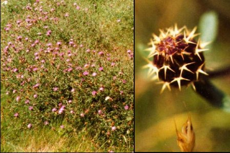
Across the road, between the road and the railway, lies a rough area of common partly occupied by a flat topped spoil hillock, probably the site of an earlier gun battery from the 1790 period. This part of the common was dedicated about 10 years ago to the use of the local youngsters as a motor cycle scramble course. Right in the middle lies an area about 25m square, the only site in the island of the Rough Star-thistle Centaurea aspera, (photo below). First recorded by E.D. Marquand about 1890, here as a small patch a few yards square and also on the other side of the road nearer the sea, (now gone), this has survived for more than a century and, although one of the motorcycle tracks down from the top of the mound runs through the middle of one of the larger clumps, has retained its hold, whilst failing to spread to any other sites, either naturally or despite the attempts of several people over the years to spread the seed. By contrast, the same plant on St. Ouen's Common in Jersey, described early last century as existing only in a small patch, has spread to cover much of the common today and makes it an uncomfortable place to sit, as you can imagine from the spines shown in the photo.
About 1996 Alderney Electricity were putting their cables underground and the trench went right through the middle of the other large patch a few metres away. By their co-operation and careful marking of the spot to avoid unnecessary disturbance of the remainder of the colony, the narrow trench needed for the cable only destroyed a handful of plants and within a year or so was undetectable.
Erosion of the low cliff in front of the seats nearby has resulted in a recent strengthening of the sea wall and the rocky beach in front of these is a favourite place for several species of waders, including small flocks of Curlew, Oyster Catchers, Ringed Plover and Dunlin, from time to time and on migration and the very occasional Grey Heron.
.
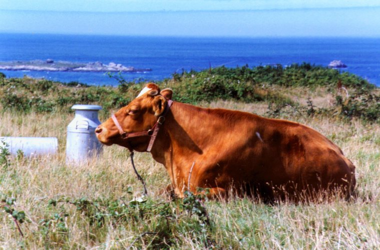
Figure 33. Alderney (Guernsey) cow tethered on Braye Common
The whole common area in late summer bears frequent plants of Fennel, (Foeniculum vulgare), its handsome deeply divided leaves and heads of yellow flowers making a brave show, whilst the smell of aniseed fills the air as you brush past it. Various Buttercup, (Ranunculus), species, a variety of pink or white Campions, (Silene species), various grasses, Sea Mayweed, (Tripleurospermum maritimum), with its prominent White, yellow centred daisy-like flowers, dark green deeply divided leaves and often reddish stems and Pineapple Weed (Matricaria discoidea), similar in general appearance, but lacking the white petals surrounding the yellow-green head, are frequent on the barer patches; many plants of Gorse, bearing flowers for much of the year grow along the top of the low cliff formed by the dunes.
A number of smaller and usually less conspicuous plants flourished in the short cropped turf.
With the considerable decline in agriculture in the island over the last 10 years, grazing gradually ceased and in order to keep the area tidy for both islanders and visitors to walk and play on, the States commenced a frequent mowing policy, leaving the cuttings on the ground and, over 2-3 years, effectively suppressing the growth of most of the smaller plants and the orchids
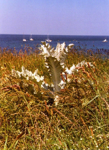
Figure 34. Cotton Thistle
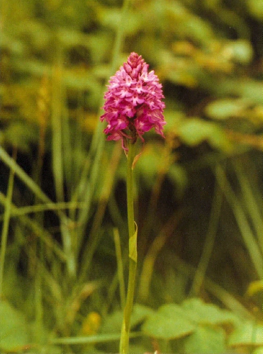
Figure 35. Pyramidal Orchid
 ..
..
Rough Star-thistle
All on Braye Common..
The remainder of the N. coast of the island will be dealt with in Regions 6 and 7.
. .
.
