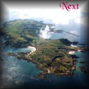
This small triangular region is bounded to the North by Braye Common and the Rue de Beaumont, renamed some years ago in honour of our twin town across The Race, but still better known to the islanders as the Lower Road or Le Banquage. This area contains a substantial part of the Banquage housing estate; a small industrial area; the Pine plantation; Battery Quarry, the island's principal reservoir; a length of the Victorian mineral railway; still in use today as a tourist attraction; the steep slope up to Les Rochers with various Neolithic remains; the Valongis, a damp valley with springs a Sycamore wood and a rich fern flora; one of the old abreuvoirs publiques and a small quarry; Champs Beaulai, a small 1960-70s housing estate; the Cimitière St. Michel (Stranger's Cemetery; the Catholic Cemetery; the new, (as yet untenanted), extension to the island cemetery; and a considerable part of the Golf Course.
The eastern half of the region is largely composed of an enormous blown sand dune, running over the top of the island between Braye and Longis Bays, of an age which has never been positively determined, but which covers some archaeological sites up to 5,000 years old.
It is bounded to the South by the Longis Road, here running downhill from the top of the Town.
Within its boundaries, the hand of man has, over the centuries, greatly modified the landscape. Just in and beyond its eastern end, a large early Iron Age pottery has been excavated at Les Huguettes, in an area called, for considerably more than a century, 'the potter's field' by the islanders, because of all the bits of broken pottery and other ancient bronze and stone tools found there. Many Bronze Age and Roman artefacts have been found and the island's earliest permanent settlements probably existed in this area, (of which more in Region 6).
On top of Les Rochers, Neolithic stone circles were found in the 1830s, partly already destroyed by fortification works in the previous century. There still exists the old Magazine, from about 1760-90, incorporated into a house in the 1990s. The distribution of the Crown Lands to the inhabitants in 1830 meant that a lot of ancient burial sites were destroyed, through the new owners cultivating or building on the land and breaking up the graves and standing stones they found, for their own constructions, whilst remaining largely ignorant of the significance of what lay beneath their feet.
The Victorians built the railway track around 1846-7 and subsequently, in constructing the breakwater and forts, excavated vast quantities of granodiorite from the quarry formed where the old Kings Battery stood, built at least half a century before, some way below the Magazine and the site next to it, (marked on old War Department plans, of a projected fort which was never built).
The Germans built many bunkers on it and tunnelled underneath parts of it during World War Two and the settlers had houses built on it after the war. In at least one of the plots, huge stones, probably put in position by ancient inhabitants, were found when excavating the foundations for a new house. Some were rolled into line to form a feature in the north sloping garden. Finally, in laying out the present golf course, other remains were disturbed, but the extremely important discovery and subsequent excavation of the pottery site mentioned above, resulted from this same activity and the site was preserved for posterity, with many of the artefacts now on display in the Museum.
To start the survey of this region, we can perhaps best follow the track of the Victorian mineral railway, built to carry stone from the quarries for the construction of the Breakwater and Forts. This enters Region 5 on our map just behind the Banquage housing estate. Although this ceased to be used for the transport of stone in the 1960s, in recent years since it was leased to the Alderney Railway Society for their passenger trains it has become a tourist attraction. From time to time the length of the track from Mannez quarry to the harbour is sprayed with weed killer, but is otherwise little disturbed. A number of interesting plants are found in the banks either side and, between the infrequent sprayings along the bed of the track.
Of greatest interest perhaps is the Alderney Crane's-bill or Alderney Geranium Geranium submolle. This plant was first noted along from here, to the level crossing by Battery Quarry in 1938 and was considered to be a variety or colour-form of the common Dove's-foot Crane's-bill G. molle. (Later research showed the same plant to have been collected in Guernsey in 1926, when it was named G. Core-Core and was not seen again until found in a totally different spot in 1968). Refound in 1957 and now found in other sites in Alderney, it has been given species status in .the.last 5-10 years. It seems to be identical to a species of South American origin but is not found elsewhere in the British Isles.
.
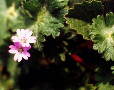
Figure 40. Dove's-foot Crane's-bill.
The newcomer grows to about 80cm, scrambling and with larger, less deeply notched flowers on longer stalks than the common, generally small, low-growing and almost ubiquitous Dove's-foot. It is now found all along the track sides and the verge in Newtown Road within about 100m of the crossing and in other lengths of the track nearer Mannez quarry, in Barrackmaster's Lane and several other scattered localities.
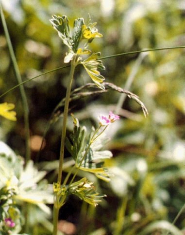
Figure 41. Alderney Crane's-bill
A few metres the other side of the Battery crossing track sides are home to a small colony of Blue Fleabane Erigeron acer, small, with not very conspicuous mauve florets. Although this has been recorded regularly since 1838 it does not seem to be very common elsewhere in the island..
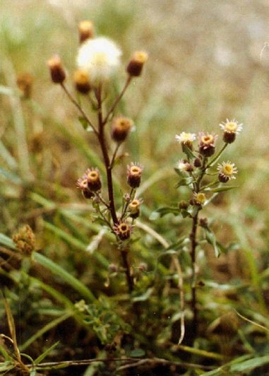
Fig 42. Blue Fleabane
In the verge on the opposite side of the road, an unusual looking fungus the Earth-star Geastrum triplex, has appeared on a number of occasions and I have also found it across the road from the southern boundary of this region on top of the bank opposite the new cemetery in Longis Road. It has also been reported near Mannez quarry.
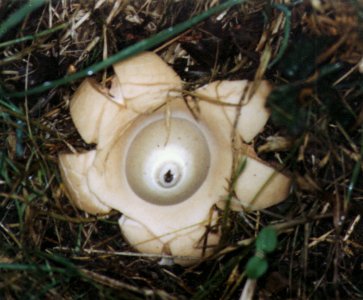
Fig 43. Earth-star
Moving into the nearby Battery Quarry from which many thousands of tons of the hard Granodiorite stone was excavated from about 1846-1940, creating a large hole reputedly about 200 feet deep, we are at, what has been since the last war, the island's principal reservoir, currently in March 2000, almost full to capacity and holding around 45 million gallons of water. The freshwater flora of this quarry has not yet been investigated to the best of my knowledge. The relatively undisturbed, narrow area of ground level quarry floor on two sides of the quarry hole does not seem to hold anything special of botanical interest, whilst the high walls surrounding it to a maximum height of about another 100 feet, bear many common ferns, lichens, mosses and flowering plants. Above the quarry rim to the east, a small colony of Agrimony Agrimonia eupatoria, may be found. This is rare in Alderney.
.
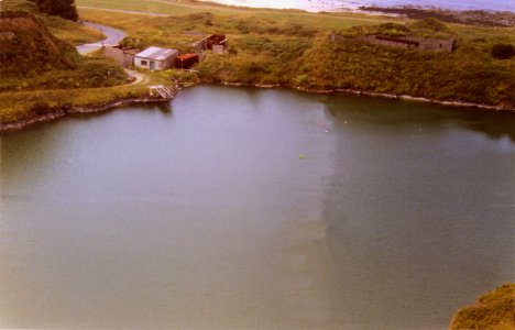

..................Figure 44. Battery quarry from the SE rim.. ...............................................Figure 45. Agrimony
On the steep, upward, slopes of Les Rochers, to the south of Newtown Road, in addition to post-war and more recent housing developments in Valongis and along the north facing slope, a mixed Pine plantation was made in the 1960s. This small area is now densely populated and the under storey is more or less sterile from the litter of pine needles. Specimens of Scots Pinus sylvestris, Austrian P. nigra subsp. nigra, Corsican P. nigra subsp. corsica, and Maritime P. maritima, pines are mixed and at least one specimen of Knobcone Pine P. attenuata, can be found with them.
The undeveloped parts of the slope are densely colonised by Gorse, Bramble and Bracken with many self sown Sycamores, Hawthorns and, at the top, a considerable area in which Traveller's-joy or 'Old Man's-beard' Clematis vitalba, surprisingly rare in Alderney, may be found amongst the German bunkers. A small mystery exists along here in the form of a large, dense, almost circular patch 15-20m across, of what seems to be Lilac Syringa vulgaris, despite its size and regular visits at the appropriate flowering time, I have never seen this in flower. On the south side of the rough track along the ridge here, towards the western end and the junction with Valongis, lies an area of Church glebe land. Untended for many years, amongst other (all presumably planted, shrubs), this has some large bushes, 3-4m tall, of Spanish Broom, Spartium junceum, its large, brilliant yellow flowers making a welcome patch of colour for many months in the year. Along the sides of this track one may also find scattered plants of another, here in Alderney surprisingly rare, perennial plant, Meadow Crane's-bill Geranium pratense, its large, usually blue to violet-blue flowers, sometimes pale pink instead. This phenomenon has been noted elsewhere in the island and seems to affect individual plants only in some years.
Turning south at the junction, on the left, the lower end of the glebe land, just above the Cimitière St. Michel, was used by the Germans during the last war as a cemetery for their own troops. The bodies were all repatriated in the 1960s. The Stranger's Cemetery (St. Michel) was established during Victorian times for burying the immigrant workers and troops on what was thought to be the site of an ancient chapel of one of the 'frairies', established by a monk or hermit who gained his living by saying masses for the souls of the dead. There were several in the island, dedicated to various saints and disbanded by Henry VIII in his sequestration of the monasteries. The small revenues from each were annexed to the crown and the sums appear in an "Extente" in the reign of Elizabeth I. This cemetery is the site of the island's only known colony of Cowslips Primula veris, never in any great numbers and, in some years, greatly endangered by States mowing the grass at inappropriate times. In 1998/9, the boundary wall to the east of the plot was removed, a new roadside wall built incorporating the stones along the adjacent field, which has been allotted as an extension to the Parish cemetery.
Partly adjoining this field, to the east again, with a house built between it and the road, is the Catholic Cemetery, established in the early 1860s. After the Reformation, the Parish church continued as the only place of worship, with compulsory attendance for all, under threat of fines for non-attendance and all were buried in the adjoining cemetery or in their family vaults in the old cemetery. With the huge influx of stonemasons, labourers and troops from 1846 onwards several other denominations built places of worship and a Catholic church was established at Crabby Bay from 1852. Registers of their births, marriages and deaths exist from about 1857 and the first record of a burial in their cemetery is in 1868. There seem to be no specially important plants here, although a patch of Chicory Cichorium intybus, thrived for a number of years in the 1980s - mid 1990s, just outside the gate. The tombs and walls have an interesting lichen flora which was catalogued in 1997/8.
Continuing to the east down the Longis Road, the bank along the northern side holds a mass of white flowers of the Sweet Alison Lobularia maritima, along most of its length, a southern European plant well naturalised throughout the island and in flower in every month of the year. This bank also has a heavy growth of the ubiquitous Three-cornered Garlic ('Stinking onions'), also a naturalised Mediterranean immigrant, in the Spring giving a dense bank of white flowers with a pale green stripe down the back of each petal. Some old, planted, Lawson's Cypress and Monterey Pines, over a large area of German bunkers, along this side of the road, lead to a belt of Gorse, Hawthorn and Bramble separating part of the golf Course from the road and then recently planted trees and older belts of the same species down to the former WD Officer's houses at Simon's Place and the end of Region 5 at the junction with the railway line and the Rue de Beaumont.
.
