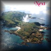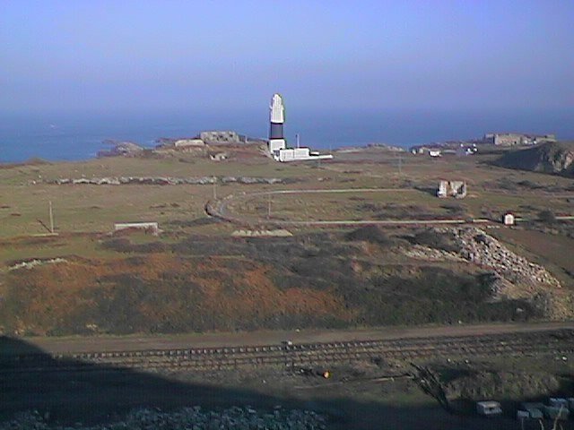
Figure 61. NE coast with Alderney Lighthouse, Mannez Quarry
and Forts. Les Hommeaux Florains (L Centre) & Quesnard (R),
looking N from Mannez Hill
This part of Alderney is a naturalists paradise. It contains so many endangered, rare, scarce, or uncommon, plants and such a wide variety of fauna, that it would be declared a Site of Special Interest and protected, if only we had a Wildlife Conservation Law. Some of these species are important in an international context, the others only as far as the island is concerned, often being their only recorded sites.
As it happens, most of the species concerned are not particularly prominent, would pass unnoticed by the majority of people and many need a hand lens to appreciate their true beauty. The former public road along the whole length of the East coast is no longer used by vehicles, except by the few idiots who ignore the prohibition notices at either end, (put up to prevent further erosion), having been superseded by the road put in by the Germans, about two hundred metres inland, during the last war.
The area between this road and the sea is between five and 30 metres above HWM, backed by Mannez Hill, rising to about 75m, a huge part of which was removed by both the Victorian and German quarrying activities, leaving the floor of Mannez quarry at about 10m above sea level. Exposed on parts of the two remaining outcrops of soil, 'head' and rock (one on R hand edge of the photo above), are remnants of the 8 and 18 metre raised beaches, left from the last two ice ages. To see the pictures click the underlined blue links.
The old quarry Powder magazine at the west side of Cat's Bay, (the indent in the coastline at the left side of the picture above), has one of the few island colonies of Common Scurvy-grass Cochlearia officinalis, alongside (see picture). Just to the right of the Lighthouse on the narrow coastal path is one of the two colonies of Lesser Meadow-rue Thalictrum minus and, a few yards further on at the roadside a clump of Red-hot Poker Kniphofia praecox, probably escaped from the cottage opposite, has flourished for many years and has at least one flower head open in most months of the year.
Fort Quesnard on the NE corner of the island on "Duck Point" has had the Victorian gun emplacement on its seaward side augmented by the Germans. In one of these additions a pair of Barn Owls have nested regularly for some years.
Along the east coast, whilst predominantly shallow and sandy over the underlying sandstone rock, the soil pH changes in a number of places from alkaline to acid and back, often within a few yards. These can be clearly seen by changes in the vegetation, with an area of Heather (Calluna vulgaris) and Bell Heather (Erica cinerea) on the headland by St. Esquère Bay where the soil is acid and peaty and several changes in the Stonecrops, abundant in the short turf all along this coast, where the bright yellow-flowered Biting Stonecrop Sedum acre (see picture), which prefers alkaline conditions and the pink and white-flowered English Stonecrop S. anglicum (see picture), which prefers acid, can be seen to alternate. The alkaline areas are frequently obvious from the large number of tiny mollusc shells on the surface, which have given them their basic nature.
In the track formed by soil building up over
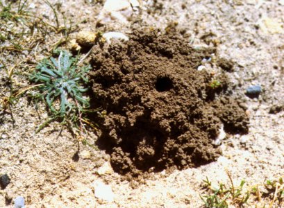 the old gravelled road bed, you will note frequent evidence of a number of burrowing, mainly insect species. Holes about as wide as your finger, usually with a neat 'volcano' of soil about 5-10cm wide around them (Fig. 62 on right) are made by an animal species, possibly a beetle, which I have not yet been able to identify. Smaller holes often drilled in the vertical sandy edges of the grass above the rocky foreshore, are made by burrowing wasps, of which there seem to be a number of species. The length of the trackway was the first recorded place in Alderney where Gatekeeper Butterflies were noted, by my wife and I, in August 1996 and annually since, in gradually increasing numbers. A migrant species which may now be breeding here, the males arrive up to two weeks before the females.
Rabbit droppings, burrows and scrapes are common along here and, in the large field behind St. Esquère Bay a large warren can be seen at the edge of the bracken, with black rabbits frequently seen amongst the normal brown.
Starting along the track from Fort Quesnard to Longis Bay; in just a few yards we come to a slight depression about 10m by 3m, with thin bare-patchy soil over the bedrock, about 20m from the beach edge, usually damp or occasionally flooded in the winter and bone dry in the summer. Here one finds from early February to the end of May or the beginning of June, a substantial number of the small rosettes of the rare Sand Quillwort Isoetes histrix (see picture), a fern-like plant which exists mainly underground, the emergent fronds looking, at first glance, much like the narrow leaves of the many plants of Buck's-horn Plantain (picture above r. and p. 52) and Autumn Squill Scilla autumnalis (see picture), found in the same place. Bright green at first, by the end of May their spores are shed up the narrow funnel in the centre of the rosette and they turn olive green before drying up completely. They are most easily found at the olive green stage by the contrast with the other plants. In sloping turf close by, a good colony of Yellow Bartsia Parentucellia viscosa (see picture), exists. Most of the plants are short not more than 25-30cm unless the wet season is prolonged. In a parallel line extending some 2-300m from this spot, four more small colonies of the Sand Quillwort can be found, the most southerly being the largest. Close to the edge of the narrow rocky beach between the middle two colonies, you might find, if conditions are right in May and June, our only recorded colony of Lesser Centaury Centurium pulchellum (see picture), a Red Data Book Endangered species. Common Centaury C. erythrea (see picture), is frequent in the shorter turf and trodden path all along this coast.
Within a few feet of the Lesser Centaury, you may also find a small area of Blinks Montia fontana (see picture ), and another of Allseed Radiola linoides (see picture ), two tiny annuals, difficult to find and identify with certainty, which are not commonly noted in the island, although they may well be much more common than would appear from the records.
Just beyond the last group of Quillworts a large patch of Pink Oxalis has been spreading over the years in front of a stone wall and beyond that again, fortunately usually hidden in the bracken, whilst they are flowering, several large clumps of Cyclamen have been similarly spreading. Probably originating from garden escapes or throw outs, over the last 15 years these have spread considerably. Their leaves appear in very early spring and the flowers from August on. Most seem to be the usual pink Cyclamen hederifolium (see picture) but there were a few smaller clumps of white flowered plants, which had survived a good few years until someone dug most of them up in Autumn 1998 as the bracken died down.
All along the rocky shore edge, considerable amounts of Rock Samphire Crithmum maritimum (see picture ), can be found, flowering in most years from late June to October. A somewhat larger area of pebbly beach exists before Fort Houmet Herbé, perched on its tidal island (see picture ). The grass at the edge of this holds a narrow line of White Stonecrop Sedum album (see picture), and amongst the worn sandstone outcrops, rising a little in height as you near the water's edge, more special plants can be found. Rock Sea-lavender Limonium binervosum (see picture), is scattered, rooted in the crevices between the rock strata, with the occasional plant here of one of Alderney's two speciality, named plants, the Alderney Sea-lavender L. normannicum (see picture), and a few plants of Sea Aster Aster tripolium (see picture). In a small salt slack, basically almost a tidal pool at spring tides, two rushes; Sharp Rush Juncus acutus and Sea Rush J. maritimus (see picture) may be found, the latter also with a few scattered plants at the edge of the shingle beaches further along this coast towards Longis.
Among the edges of the rock strata on the higher level nearer the sea, a much larger colony of the Alderney Sea-lavender may be found with a few plants of the Rock Sea-lavender. Mixed with these, the delicate pink and white flowered Sea-milkwort Glaux maritima (see picture), run along several of the strata lines in the sandstone, with the main colony of Sea Aster, rarely numbering more than 20-30 plants in the crevices above it. All the plants of this in Alderney have white flowers, whilst the usual form found elsewhere is blue (see picture).
On the next headland with the unusual site of some very large plants of Agave planted along the outside base of a garden wall many years ago which have produced a few suckers, we are on a section of heathland. A considerable patch of Heather and Bell Heather is, for a week or so when in flower, covered in most summers with hundreds of day-flying Silver-Y Moths. This whole small headland has thousands of plants of Sand Crocus (see Figure 55 p. 60), each with its single mauve and white star-like flowers in early March to May, just emerging from the rosette of narrow curved leaves on bright sunny days and impossible to find on a dull day. There are also thousands of Autumn Squills, whose leaf rosette is very similar to the Sand Crocus. these however do not flower until August or September (although last year we recorded the first blooms on 29th July).
In early April a few Green-winged Orchids Orchis morio (see picture), appear on this headland and in the lawn of the garden just behind the wall. Wild Thyme, Common Milkwort, Common Centaury, English Stonecrop, Carline Thistle, Smooth Cat's-ear (see picture), Thrift and several other small plants may be noted on this highly interesting headland, barely 50 x 30m in extent. In 1997 a sharp-eyed walker noted an unusual small bush just emerging from underneath one of the 45º inclined strata of rock, with a hollow beneath it, almost at the highest point of the area. I was called and thought, from its glossy, aromatic evergreen leaves and tiny pink buds that it might be a Myrtle, never before recorded in Alderney. It was obviously several years old and highly unlikely to have been planted there, with its roots a about 70cm back where the inclined rock emerged from the soil. The gap between the soil and th
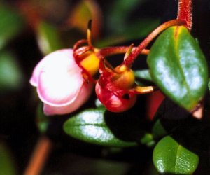 e front edge of the rock was well filled with a Fescue grass and the woody stems were struggling through this to reach the light. Several visits failed to find the flower buds open, but later in the year some dark red-black berries were noted. The following year I managed to catch it in flower (Figure 63 on right) and it confirmed the Myrtle identification, but it was not until the summer of 1999 that it was finally confirmed as the Chilean Guava (Myrtus ugni). At this time two seedlings were noted in the grass within about 30-40cm. The source of this Chilean plant however remained a mystery until the owner of the nearby house said she had planted several different Myrtles some years before and it was found in her garden.
At several points along this lady's east facing garden wall some very large tree sized (to 7m) shrubs of Ake-Ake Olearia traversiii, have survived the worst that winds and salt spray can throw at them and produce hanging pyramidal axillary clusters of tiny yellowish, Groundsel-like flowers, from June to August. Amongst a group of Monterey Pines on the N side of her large garden, there is also a large area of self-seeded Giant Echium, some of which reach 4-5m in height in their third year before flowering and dying. This Echium is common in the Channel Islands, a far cry from its native habitat in the cloud zone above 2,000 feet in the Canary Islands and a spectacular plant in summer, which often amazes visitors walking along the coastal track (see photo p. 54).
At low tide there is a nice sandy beach in a small bay to the south of this headland and, on its far side on an east facing bank a few metres square and barely 3m above the beach a wealth of rare plants in due season. Most important is the Red Data Book endangered species, Small Restharrow Ononis reclinata, a tiny annual, usually with pink and white pea-flowers (see Figure 56 page 60), but occasionally found with white flowers. This was not seen for several years between 1981 and 86, but refound at its usual spot by the author that year. In the same spot look for Small Hare's-ear Bupleurum baldense, another RDB scheduled plant (photo), also found on Longis common and a few other places in the island. More Carline Thistles and a patch of Dwarf Thistle Cirsium acaule (photo) usually with one or perhaps two stemless mauve flowers in each spiky rosette, but also occasionally with white flowers and a variant with 8-10 cm high flowering stems growing from the rosette. From here along a narrow ridge just above the beach for the next 2-300 metres, look for the olive green stems and leaves of Bastard Toadflax, from March onwards with their tiny white 5-pointed flowers seen from May to October or November.
This same bank holds more interest. More Smooth Cat's-ear Thyme-leaved Sandwort, Biting Stonecrop, Lesser Parsley-piert, Aphanes inexspectata, and other minute plants such as the two small Forget-me-nots mentioned on page 53. There are several large cushion shaped bushes of Wild Privet Ligustrum vulgare, more Green-winged Orchids by the rock known as La Grande Folie and both pink and yellow forms of the Hottentot Fig and the smaller, less common, puce-coloured Sally-my-Handsome Carpobrotus acinaciformis, both well established aliens in our flora. Bracken and bramble are found along the whole length of this track and Marram Grass starts in the dunes towards its southern end. Here look for two very large plants of Sea Rush in the stony beach at the edge of the grass and a large amount of English Stonecrop, leaves often pinky red, flowers white with a red spot on each petal, alternating with the yellow Biting Stonecrop (Photo p. 66), here shows several changes in the soil pH over only a short distance. Large numbers of Limpet and other, small marine mollusc shells will be found on the grass here, contributing as they gradually break down to the alkaline nature of the soil. You come now to the back of the Marram covered safety bank at The Targets, and the huge wall built to protect some long-gone houses from stray bullets from the firing range, an area known locally as "the hole-in-the-wall" from the damage done to the wall by a German shell and only filled in about. On the bank look for the straggling plants of Knotted Hedge-parsley Torilis nodosa, amongst the coarse grass and either side of the path on the beach side of the bank and both sides of the track nearest the wall, look in August to October for the brown fingers, 10-15cm high, of Bermuda-grass Cynodon dactylon (Photo p. 69), another RDB endangered species, but here spreading quite rapidly since it was first recorded in 1956.
In midsummer this seems to be a favourite place to see numbers of the Emperor Dragonfly, (photo p. 62), probably hatched in the Longis Pond, only a few hundred metres away.
You now arrive at the small area of beach between the Targets and the start of the smaller section of the German sea wall. The sandy area above HWM is home to a few plants of Sea Kale and larger numbers of Sea Rocket Cakile maritima (Photo p. 69), another member of the cabbage family, with white to pale mauve flowers and pale green foliage. This is also found in small numbers scattered along the beaches at Platte Saline and Braye bays. A small area of moving dunes still exists in front of this part of the sea wall and also beyond the causeway to Raz Island, in the unfinished area up to the major part of the German defence wall. Many of the plant and animal species common in such habitats will be found here. Amongst the plants, most already mentioned in this work, we may find Sea Bindweed, Sea Spurge, Sea Sandwort, Marram and several other grasses, Gorse, Bramble, Dune Stork's-bill, Round-leaved Geranium, Chickweed, several Mouse-ear and Campion species, etc., etc.
In the rock strewn littoral zone here (Photo Fig 64 below), at low tide, areas of exposed peat will be seen. These were formed thousands of years ago when the sea levels were much lower than now and this part was probably the bed of a freshwater lake, reduced in historic times to the far smaller area of Longis Pond. In it many stone-age artefacts have been found, including two wooden spears about 4,000 years old and several bronze-age axe heads from between 2-3,000 years old. Some of these items will be found on display amongst the many archaeological finds in the Alderney Society Museum. A recent find in February 2000, after some stormy weather, was a 'dump' of broken, pre-Roman, rotary querns with several large pieces clearly showing their construction, exposed after the sand covering them for many centuries was washed away. The best of these are now on display in the Museum.
The causeway forms the boundary of this zone of our ecological review and also happens to fall almost exactly on the map grid line separating the 10Km squares numbered WA 50 and 60. For wild life recording purposes, these 10Km squares, known as 'hectads', are used to separate boundaries and lists and maps for the distribution of species of both plants and animals are based on them. Alderney's small size makes it more convenient to further divide these into the 1KM grid squares for local records. These are numbered 1-14 on the Alderney maps found on this website and in the author's newly published book The Wildflowers of Alderney.
The recent Atlas of the British and Irish Flora, the Botanical Society of the British Isles contribution to the Millennium records, published in 2002, contains a dot for Alderney in each of 3 hectads in which any given plant has been recorded, (the only land in the third hectad, WA 40, being the Casquets rocks about 7 miles west of the island). This Atlas updates and greatly expands the similar 40-year old volume, and all the BSBI Vice-county Recorders, including the author, were busy over the last 4-5 years of the 20th Century updating, researching all possible old records from herbarium species and scientific publications, some going back more than two centuries and computerising all their plant records, which have now been fed into a national database of many million records, from which the maps have been produced. Alderney's small land area amounting to barely 9 sq. km has the largest 'flowering plants per square km' species count in any one Vice-county in the British Isles (including Ireland) with some 1,052 recorded in total, of which at least 800-850 may still be found today.
It is a matter of some regret to the author that, apart from a fairly comprehensive set of bryophyte, bird, dragonfly, butterfly and moth records over the last 30-40 years (see the links at the bottom of the contents page of this item), post 1920 records for other plants, fungi, seaweeds and more primitive freshwater plants, (Charophytes, etc.) and accurate, comprehensive and up-to-date lists of, mammals, fishes, or any of the many thousands of other insect, mollusc and other animal species, etc., did not exist until 2004-8 when they have been greatly expanded by members of the Alderney Wildlife Trust, a process still continuing with the establishment in March 2008 of the interactive Alderney Records Centre on the Internet, to which members of the public can add sightings.
For some of these groups, considerable study was done in Alderney, in the late 19th century, mainly by members of La Société Guernesiaise, with other records from a few visiting British and French naturalists, when there seem to have been far more expert naturalists, (even if mostly amateur), with time to carry out such studies in small, relatively remote (and perhaps considered unimportant), areas such as Alderney. The small population of Alderney, with few residents ever having the necessary expertise, plus the possible loss of any pre-war records there might have been in the island, during the German occupation from 1940-45, when virtually all the historical documents, Court, States and Land records also vanished, leaves an unfortunate and now permanent, gap in our knowledge of both the history and natural history of the island, compared with most other places in the Channel Islands and the British Isles generally.
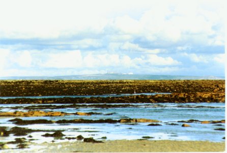
Figure 64. The area of the peat bed & reef photographed from Raz causeway,
Cap de La Hague beyond
.
.
