After leaving the previous Section, you are soon above the Cachalière quarry, the old military road turns sharply inland and then runs behind a field behind the quarry. There is a somewhat overgrown coastal path going straight on here, on private land above the top of the quarry. The pier below, was partially destroyed by the Germans during the Second World War, to prevent its possible use as a landing point for a British invasion,
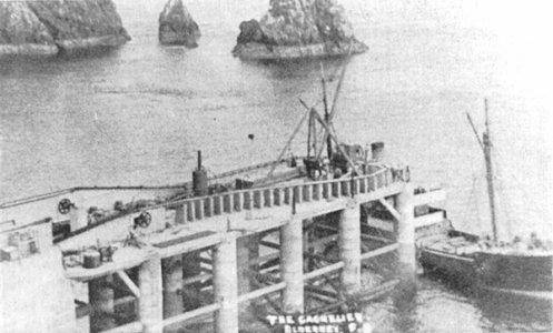
The quarry was the scene of great commercial activity for some 30 years until the unfortunate wrecking of the main cargo boat, the SS Tyne with the loss of five lives on 12th January 1922. Docking at the jetty was always hazardous and limited by the tidal state although the quarry had a very efficient loading system for crushed roadstone. (see Fig. 87 below, with SS Tyne loading stone about 1920). As a result of this tragedy the quarry was closed a couple of years later and the machinery was dismantled a few years after that.
Soon you come to Les Quatre Vents, until recently, an ordinary, quite attractive house, the only building ever permitted on the south cliffs, erected about 1936 by the man who started Alderney's original land-based airport. This was
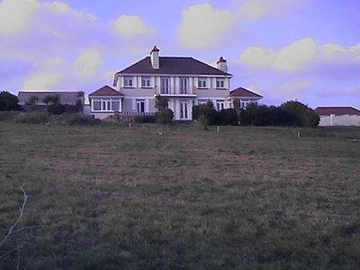 bought by a wealthy Belgian about 1996/7. An unwise planning committee, perhaps blinded by wealth and a promise to create an associated educational centre, at which local students could be taught agricultural skills, granted permission for an ...Figure 88. Les Quatre Vents, two days
before demolition
bought by a wealthy Belgian about 1996/7. An unwise planning committee, perhaps blinded by wealth and a promise to create an associated educational centre, at which local students could be taught agricultural skills, granted permission for an ...Figure 88. Les Quatre Vents, two days
before demolition
"extension" to the house. Within days of the consent being given, the entire house vanished in a single day and an enormous prefabricated structure was started some distance from the original house. The 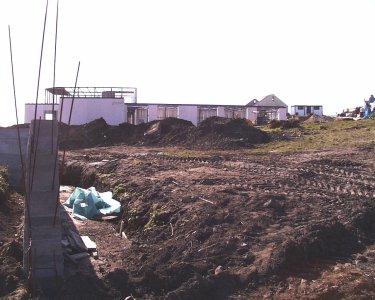 specialised nature of the construction plans persuaded the States to allow Sicilian building workers (and their families) to come to Alderney, Work Permits were issued for specialist terrazzo and marble workers, at least some of whom subsequently proved to be no more than labourers....... ......... ...........
The families reputedly lived illegally on the site, in a former large shed with no proper toilet facilities and few other amenities. The foreman spoke no English and could not communicate with the States Surveyor, plans were not adhered to, some of the structural steel used proved inadequate for the weight it had to carry, the public coastal path was obstructed for weeks at a time, a tunnel was built underneath it to link to the adjacent Vau du Fret, which formed part of the property and a ghastly concrete wall was built round the path boundary more than
...Fig ..89. The new building at an early stage.... double the height of the former local stone wall and a stop was put on the building works on several occasions whilst planning requirements were revised.
.
In late 1999 after a second huge public outcry, petitions to the States and considerable adverse comment on the ability and sense of the members of the Building and Development Committee, all work ceased and the workers left. By this time the building was two storied, with a high, incomplete, collapsing roof, large holes had appeared in the floors of the upper storey, steel girders were ru
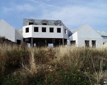 sting and some had sagged and the walls seemed to be mainly composed of large, thin, prefabricated panels.
Several local contractors had court cases pending against the owners for non-payment for their services and parts of the building seemed in danger of collapse. In April 2000 after more discussion in the States Meeting it was suggested by the two principal committee chairmen, at least one of whom had been involved in permitting the fiasco in the place, that a compulsory purchase order should be taken out on the property and the entire structure demolished. This met with great public approval but, so far (November 2000), no action has been taken.
.................................Fig 90..The partly built structure 11.9.2000, after being abandoned for 11 months >>
Later promises, made early in June 2000 by the owner, to rebuild parts not constructed in accordance with the plans and continue the work within one month, were still unfulfilled when this picture was taken. The site was abandoned by the workmen who returned to their native country and for 2-3 years no further progress was made. Eventually the States order to partially demolish the structure to remove the rusted steel joists which had allowed the upper floors to collapse in several places and to replace much of the exterior wall structure, which appeared to have been constructed of large panels of compressed polystyrene granules and to comply with the original specification for the materials, was carried out some time in 2004-5. the two side arms of the building were reconstructed and roofed over with more traditional materials and there, in 2006 the situation remains. As far as I can see the building is still not completed nor in use.
.
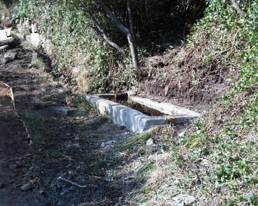 Work nearby, the second project for the recently formed Alderney Conservation Volunteers, over the weekend of 8-10th September 2000, assisted by members of the Guernsey group and organised by Roland Gauvain, Alderney's Conservation Officer, (a six month trial post recently extended for a further six months), in clearing and draining the boggy area round one of the old Abreuvoirs Publiques, (Fig. 91 above), where the Victorian 25 foot Military Road passes across the dip in Le Vau du Fret at the eastern side of Quatre Vents, repaired and exposed the trough fully, for the first time in many years and replaced the blocked drains where the Fret stream was formerly piped under the trackway. Altogether a worthwhile job, well done.
On the cliffs in front of the Quatre Vents site are some of the few plants of Common Broom Cytisus scoparius in the island. Continuing to the west, the path dips down into the Val du Saue. Commonly called, (and on some maps shown as) the Val du Sud (South), the proper name means Willow Valley. Well watered by a short stream which drops over a 10-15m cliff into the sea, to the north of the path the area has been cultivated at various times in the past as a market garden. It has also been planted, many years ago, with a variety of uncommon plants. Contorted Willow Salix matsudana has reached a considerable height. In this species the twigs are twisted and bent into many directions and even the leaves are twisted. There is a large patch of Giant Rhubarb Gunnera tinctoria beside the stream, its huge leaves up to 1½-2m across on petioles up to 2m tall. The fruiting stems are up to 1½m tall. Several Cupressus species and, beside the wall bounding the old military road a large, suckering patch of the deciduous Elaeagnus commutata, (Fig. 92below) looking at first glance like one of the many willows in this area, in June/July this produces many tiny, sweet-scented, yellow, bell shaped, flowers in the leaf axils.
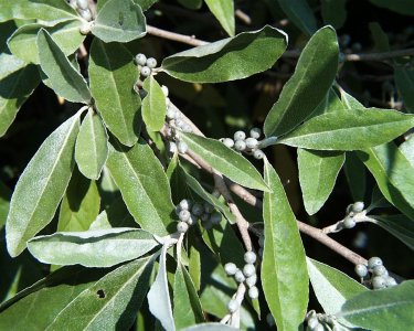 Almost spherical silver fruits are developed in September, There are two other Elaeagnus species frequently planted in the island as salt and wind resistant hedges. Both are evergreen, flower late in the Autumn, with white or silvery flowers and produce thin coated oval green or silvery fruits, turning red in early spring. Much favoured by birds, each with a single, pale brown, hard cased seed, these germinate quite frequently where they are dropped.
Below the road on the seaward side is a plantation of various pines and other trees and a number of bog plants will be found at the sides of the stream.
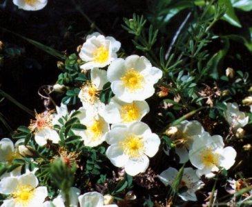
At the top of the rise, now almost buried under encroaching Ivy on top of the wall, is one of our few colonies of Burnet Rose Rosa pimpinellifolia (Fig. 93 below). Beyond this the former road
 which we have been following, no longer fit to be used by vehicles becomes a more obvious roadway where it is joined by the track from the top of Little Street, passing the end of the Airport runway. The main part of the Grande Blaye is now on your right, the greater area of this being occupied by the Airport. Between the road and the sea is a mixture of formerly cultivated fields, pasture land and Gorse scrub and along the top of the cliffs a pathway, difficult to follow in some places, and crossed by several watered valleys, in others widened by the States in 1999/2000 and with a rustic bridge built crossing the narrow stream at Vau Renier where a stepping stone served previously.
At this point, what I thought was the only site in Alderney
 of Wild Madder (Rubia peregrina), with two plants rooting virtually in the stream bed for many years, the widening process destroyed the nearest plant (Fig. 94 on right). Before crossing the bridge, coming back to the east, along a new path running uphill and then down to a spot close to the cliff edge, created through previously impenetrable bramble/gorse/bracken scrub I was happy to find, about 50m away, about a dozen well grown Madder plants amongst the gorse alongside the new path.
This part of the coast holds a wealth of our rarer plants, a few of them rare or endangered in the British Isles generally. Most important in the tiny annual, Spotted Rockrose (Tuberaria guttata). In many years this is abundant over a 2-3
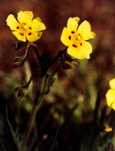 00m stretch of the path and the cliff areas beside it (Fig. 95 on right), just a few metres beyond west of the bridge. Germinating in the autumn the plants are rarely above above 5-8cms tall and each flower last only a single day, opening on sunny days and dropping its petals around noon. If you look for it in the afternoon you may well miss it altogether or only find scatted tiny petals on the surrounding ground. Another colony exists over about 60 x 10m of a field margin on the inland side of the gorse to the right of the track more or less level with this patch.
In the same area and most easily seen along th
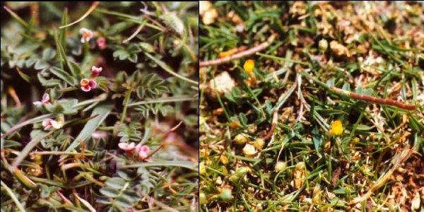 e edges of the narrow path trodden between the abundant Gorse, both species of Bird's-foot, the quite common pink and white Ornithopus perpusillus (Fig. 96 on left in photo below) and the rare (but comparatively locally common in Alderney), Orange Bird's-foot (O. pinnatus) (Fig. 97 on right in photo). Both are frequent along much of the S. cliff path and even abundant in some close cropped grassy parts, such as the Tête de Judemarre. Scattered along the path you will also frequently find small groups of yellow flowered Hairy Bird's-foot-trefoil (Lotus subbiflorus) and occasional plants of the very rare Slender Bird's-foot-trefoil (L. angustissimus). Both are normally only found in dry grassy patches by the sea and then, in the UK, usually only in the south.
Both small and large patches of another scarce yell
 ow flowered plant, Smooth Cat's-ear (Hypochoeris glabra) (Fig. 98 on right), often only 5-6cm high, but in the shelter of the edges of the gorse along the less trodden parts of the narrow track up to 10-15cm high, another species common in many parts of Alderney, but rarely seen by most British botanists, except in the east of England.
Continuing west, in a few dozen yards, a small quarry part way down the cliff has been home for at least 40 years to a single clump of Royal Fern (Osmunda regalis), the only plant in the island as far as is known. Presumably planted here, but no-one seems to know when, or by whom, it has spread but does not seem to have multiplied. Royal Fern spores were found in the peat at Longis, dated from more than 1,000 years ago, but it can scarcely be considered as "native" today. This part of the path continues to Les Couriaux headland, where a seat awaits the walker. A broad expanse of gorse between here and the old Military Road is one of the few places in Alderney where you may see Dodder (Cuscuta epithymum) actually growing on Gorse. Along the sides of this well trodden path look for Trailing St. John's-wort (Hypericum humifisum), in some quantity. An alternative path leading along and down the cliff side behind the seat will take you to the steep sided Val L'Emauve and the Lover's Leap.
On the cliff on the eastern side of the valley, at least one pair of the Ravens were nesting in Spring 2000. The opposite valley side was a mass of small wild flowers and looked almost like a planted rock garden at this time. A large number (50-60+) empty hen's egg shells were noted on a small bare patch at the summit of the valley side nearest the sea here. Obviously stolen by the Ravens from the range of plastic chicken houses in the field at the top of Trois Vaux, one of the Ravens sat above its nest on the eastern cliff face at "Krarked" at me all the time I was in its view on the westernside, especially when near the eggshell pile.
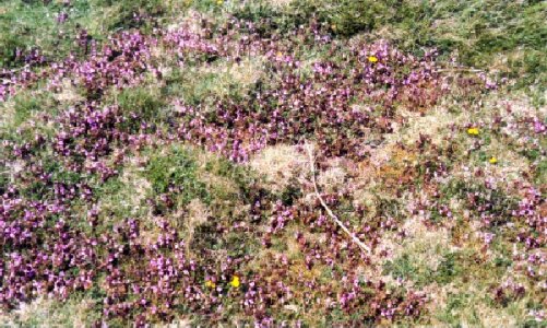 Carrying on we cross the shallow Vallée des Goudalons, which contains a huge area of Lousewort (Pedicularis sylvatica) (Fig. 99 on left), covering 2-300m x 50m, as well as many of the commoner small plants, several Speedwells (Veronica spp.), Eyebrights (Euphrasia spp.) and Forget-me-nots (Myosotis spp.).
.
.
.
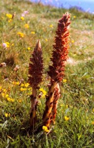
Above the west side of this valley is a former German lookout point, now converted into a sort of summer house by the owner of the Telegraph Tower 3-400m inland. From this point along the cliffs all the way to the SW tip of the island and someway round to the North from there, the cliffs are clothed with Ox-eye Daisies (Leucanthemum vulgare), Thrift (Armeria maritima) and especially with Prostrate Broom (Cytisus scoparius subsp. maritimus), the latter forming sheets of yellow flowers virtually obscuring the stems, all the way to the end of this Section of our study. Scattered frequently among the Prostrate Broom, which it parasitises, is the Great Broomrape (Orobanche rapum-genistae) (Fig. 100 below). Locally abundant here, this is only locally frequent in Jersey, absent from Guernsey, Sark and Herm and only found very locally in England.
.
We now reach the cliffs of Telegraph Bay, a veritable wild garden of flowers. Ravens used to be seen 'tumbling' here quite frequently in the spring and hopefully will soon return. The bare sandy 'head' at the top of the steps leading down to the beach is honeycombed with the holes of several species of Sand and Digger Wasps and Mining Bees, seen going in and out of their nests throughout the summer days.
.
.
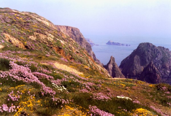
Figure 101. Telegraph cliffs
.
We have now reached the end of this section and this file was updated in July 2006.
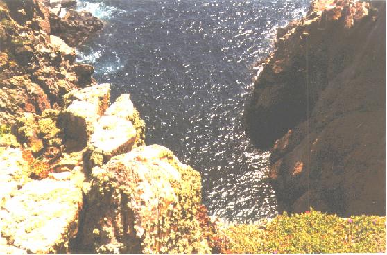
The photograph below shows the atmospheric chill of a late December morning looking down into the sea, from the edge of the Lover's leap